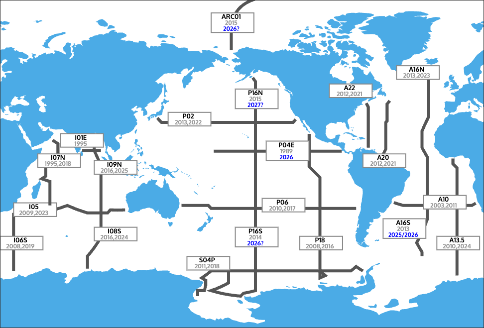
U.S. GO-SHIP

U.S. GO-SHIP
  • About
    • Vision and Mission
    • Rationale for Repeat Hydrography Surveys
    • U.S. Support for Observations on Non-U.S. Cruises
    • Cruise Organization, Planning and Documentation
    • Cruise Data Management
    • Data Collected
      • Level 1 data (Required)
      • Level 2 data (Highly Desirable)
      • Level 3 data (Ancillary)
    • Data Quality Standards
    • Data Policy
      • Overview
      • Application and Timeline
    • Contact us!
  • Cruises & Data
    • Cruise Data & Schedules
    • Cruise Maps
    • Cruise Data Submission and Download
  • People
    • Personnel
    • U.S. GO-SHIP Executive Council
  • Get involved!!
    • Students
    • Co-Chief Scientists
    • Chief Scientists
    • Postdoctoral Fellowships
    • Propose Level 3 Measurements
    • Shipboard Civility
  • Links to Programs and Data Sources
    • Data Centers
    • National Programs and Agencies
    • International Programs and Agencies
    • Historical Programs With Archived Data Resources
  • Outreach
    • Gallery
      • I06S 2019
      • S04P 2018
    • Blogs
  • Bibliography
  • News and Job Postings
  • P02 2022 Student Blog
Home Cruise Maps

Cruise Maps

Cruises for U.S. GO-SHIP, 2003 – 2020
(Red indicates a pending cruise, grey indicates a completed cruise, Blue indicates a proposed cruise)


(Map updated Sept. 13, 2021)

  • Download this map as a PNG file
  • Download this map as a PDF
  • See International GO-SHIP maps  (at go-ship.org)
  • See International GO-SHIP maps as part of the overall observing system (at jcommops.org)

This web site is supported by grant funds from the National Science Foundation. Any opinions, findings, and conclusions or recommendations expressed in this web site are those of the PIs, James Swift and Lynne Talley, and do not necessarily reflect the views of the supporting Federal agency.

Copyright UC San Diego, Scripps Institution of Oceanography | Login